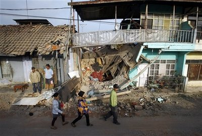
A power 7.1 magnitude earthquake struck eastern Indonesia on Saturday. No reports of immediate injuries and no tsunami warnings due to the location of the quake, an official said.
The quake struck about 47 miles underground in Papua province at 4:32 a.m. local time, according to U.S. Geological Survey. It was centered 239 kilometers east of the city of Enarotali, about 35 miles northeast of Tolikara, confirmed an official at the Meteorology and Geophysics Agency in Jakarta, according to Associated Press.
The quake was felt across many parts of Papua, including the capital, Kayapura. Hundreds of people in the area ran into the streets, fearing building collapses and aftershocks, according to Voice of America.
Indonesia is prone to seismic upheaval due to its location on the Pacific “Ring of Fire,” an arc of volcanoes and fault lines encircling the Pacific Basin.
The most devastating earthquake took place in 2004. A 9.1-9.3 magnitude earthquake struck Sumatra-Andaman Islands, causing massive tsunamis and aftershocks that claimed over 280,000 lives across the coastal areas by the Indian Ocean.


